
Page 11 - Demo
P. 11
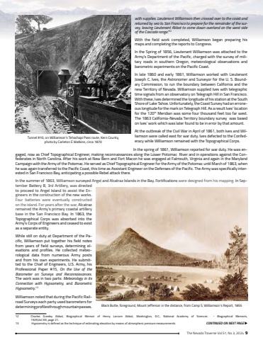
The Nevada Traverse Vol.51, No.3, 2024 9with supplies. Lieutenant Williamson then crossed over to the coast and returned by sea to San Francisco to prepare for the remainder of the survey, leaving Lieutenant Abbot to come down overland on the west side of the Cascade range.%u201d12With the field work completed, Williamson began preparing his maps and completing the reports to Congress. In the Spring of 1856, Lieutenant Williamson was attached to the Army%u2019s Department of the Pacific, charged with the survey of military roads in southern Oregon, meteorological observations and barometric experiments on the Pacific Coast. In late 1860 and early 1861, Williamson worked with Lieutenant Joseph C. Ives, the Astronomer and Surveyor for the U. S. Boundary Commission, to run the boundary between California and the new Territory of Nevada. Williamson supplied Ives with telegraphic time signals from an observatory on Telegraph Hill in San Francisco. With these, Ives determined the longitude of his station at the South Shore of Lake Tahoe. Unfortunately, the Coast Survey had an erroneous longitude for the mark on Telegraph Hill. As a result Ives%u2019 location for the 120th Meridian was some four thousand feet too far west. The 1863 California-Nevada Territory boundary survey was based on Ives%u2019 work which was later found to be in error by that amount.At the outbreak of the Civil War in April of 1861, both Ives and Williamson were called east for war duty. Ives defected to the Confederacy while Williamson remained with the Topographical Corps.In the spring of 1861, Williamson reported for war duty. He was engaged, now as Chief Topographical Engineer, making reconnaissances along the Lower Potomac River and in operations against the Confederates in North Carolina. After his work at New Bern and Fort Macon he was engaged at Falmouth, Virginia and again in the Maryland Campaign with the Army of the Potomac. He served as Chief Topographical Engineer for the Army of the Potomac until March of 1863, when he was again transferred to the Pacific Coast, this time as Assistant Engineer on the Defenses of the Pacific. The Army was specifically interested in San Francisco Bay, anticipating a possible Rebel attack there. In the summer of 1863, Williamson surveyed Angel and Alcatraz Islands in the Bay. Fortifications were designed from his mapping. In September Battery B, 3rd Artillery, was directed to proceed to Angel Island to assist the Engineers in the construction of the new works. Four batteries were eventually constructed on the island. For years after the war, Alcatraz remained the Army%u2019s primary coastal artillery base in the San Francisco Bay. In 1863, the Topographical Corps was absorbed into the Army%u2019s Corps of Engineers and ceased to exist as a separate entity.While still on duty at Department of the Pacific, Williamson put together his field notes from years of field surveys, determining elevations and profiles. He collected meteorological data from numerous Army posts and from his own experiments. He submitted to the Chief of Engineers, U.S. Army, his Professional Paper #15, On the Use of the Barometer on Surveys and Reconnaissances. The work was in two parts: Meteorology in its Connection with Hypsometry, and Barometric Hypsometry.13Williamson noted that during the Pacific Railroad Surveys each party used barometers for determining profiles through mountain passes. 12 Charles Greeley Abbot, Biographical Memoir of Henry Larcom Abbot, Washington, D.C., National Academy of Sciences - Biographical Memoirs, 1929,Vol XIII, page 21.13 Hypsometry is defined as the technique of estimating elevation by means of atmospheric pressure measurements CONTINUED ON NEXT PAGE uBlack Butte, foreground, Mount Jefferson in the distance, from Camp S, Williamson%u2019s Report, 1855Tunnel #10, on Williamson%u2019s Tehachapi Pass route, Kern County, photo by Carleton E Watkins, circa 1870
