
Page 9 - Demo
P. 9
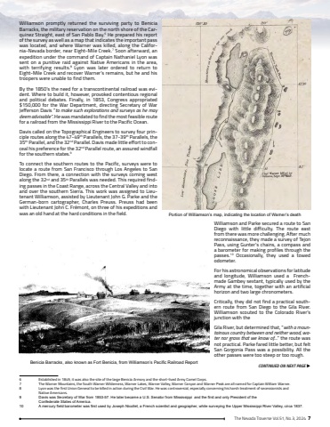
The Nevada Traverse Vol.51, No.3, 2024 7Williamson promptly returned the surviving party to Benicia Barracks, the military reservation on the north shore of the Carquinez Straight, east of San Pablo Bay.6 He prepared his report of the survey as well as a map that indicates the important pass was located, and where Warner was killed, along the California-Nevada border, near Eight-Mile Creek.7 Soon afterward, an expedition under the command of Captain Nathaniel Lyon was sent on a punitive raid against Native Americans in the area, with terrifying results.8 Lyon was later ordered to return to Eight-Mile Creek and recover Warner%u2019s remains, but he and his troopers were unable to find them.By the 1850%u2019s the need for a transcontinental railroad was evident. Where to build it, however, provoked contentious regional and political debates. Finally, in 1853, Congress appropriated $150,000 for the War Department, directing Secretary of War Jefferson Davis %u201cto make such explorations and surveys as he may deem advisable%u201d. He was mandated to find the most feasible route for a railroad from the Mississippi River to the Pacific Ocean.Davis called on the Topographical Engineers to survey four principle routes along the 47-49th Parallels, the 37-39th Parallels, the 35th Parallel, and the 32nd Parallel. Davis made little effort to conceal his preference for the 32nd Parallel route, an assured windfall for the southern states.9To connect the southern routes to the Pacific, surveys were to locate a route from San Francisco through Los Angeles to San Diego. From there, a connection with the surveys coming west along the 32nd and 35th Parallels was needed. This required finding passes in the Coast Range, across the Central Valley and into and over the southern Sierra. This work was assigned to Lieutenant Williamson, assisted by Lieutenant John G. Parke and the German-born cartographer, Charles Preuss. Preuss had been with Lieutenant John C. Fr%u00e9mont, on three of his expeditions and was an old hand at the hard conditions in the field.Williamson and Parke secured a route to San Diego with little difficulty. The route east from there was more challenging. After much reconnaissance, they made a survey of Tejon Pass, using Gunter%u2019s chains, a compass and a barometer for making profiles through the passes.10 Occasionally, they used a towed odometer. For his astronomical observations for latitude and longitude, Williamson used a Frenchmade Gambey sextant, typically used by the Army at the time, together with an artificial horizon and two large chronometers.Critically, they did not find a practical southern route from San Diego to the Gila River. Williamson scouted to the Colorado River%u2019s junction with the Gila River, but determined that, %u201cwith a mountainous country between and neither wood, water nor grass that we know of%u2026%u201d the route was not practical. Parke fared little better, but felt San Gorgonia Pass was a possibility. All the other passes were too steep or too rough.6 Established in 1849, it was also the site of the large Benicia Armory and the short-lived Army Camel Corps.7 The Warner Mountains, the South Warner Wilderness, Warner Lakes, Warner Valley, Warner Canyon and Warner Peak are all named for Captain William Warner.8 Lyon was the first Union General to be killed in action during the Civil War. He was controversial, especially concerning his harsh treatment of secessionists and Native Americans.9%u0009 Davis was Secretary of War from 1853-57. He later became a U.S. Senator from Mississippi and the first and only President of theConfederate States of America.10%u0009 A mercury field barometer was first used by Joseph Nicollet, a French scientist and geographer, while surveying the Upper Mississippi River Valley, circa 1837.CONTINUED ON NEXT PAGE uPortion of Williamson%u2019s map, indicating the location of Warner%u2019s deathBenicia Barracks, also known as Fort Benicia, from Williamson%u2019s Pacific Railroad Report
